|
OLD DEVONPORT
. UK |
||
|
© Brian
Moseley, Plymouth Webpage created: February 07, 2016. Webpage updated: May 17, 2019 |
||
|
|
||
|
GEORGE'S SQUARE BARRACKS
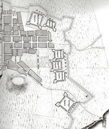
The George's Square Barracks, named in honour of King George II, was a square of single-storey buildings erected in 1757 within "The Lines" surrounding Plymouth-Dock. They were located at the South Barrier Gate, or Main Guard, just to the south of the road from the Town to Stonehouse Bridge (later known as Devonport Hill). This is the Square at the bottom of the above extract from Benjamin Donn's map of Plymouth-Dock made in 1765. Above George's Square, in order, were Cumberland Square, Ligonier Square, and Frederick Square, with Granby Square and Marlborough Square at the top.
|
||
|
|
|
|